Presenting the Water Harvesting Explorer!
A decision support tool for small scale WH interventions in the Western Sahel
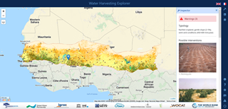
Try the Water Harvesting Explorer! A decision support tool to help identify potential for small scale WH interventions in the landscape of the Western Sahel: https://sahel.acaciadata.com/ (https://sahel.acaciadata.com/#), available in English and French!
The webtool aims to provide an overview of the sustainable small-scale interventions that may be used in the landscapes of the Western Sahel. It allows practitioners to compare the technologies based on bio-physical typologies like precipitation, topography, land cover, etc. The webtool further enables the user to plan the type of intervention by conducting a rapid survey of the implementation modalities. Overall, the webtool guides the implementers to make strategic decisions about water harvesting in the Western Sahel based on the available biophysical data. Note that on-site visits will still be needed to better assess local conditions and to make final decisions on the most efficient water harvesting interventions to be adopted.
The consortium
This tool is developed by the partners of Acacia Water, RAIN (a brand of AidEnvironment), MetaMeta, IHE Delft and WOCAT. The tool is supported by the technical backstopping partners of Global Water Partnership, Verdant Earth, Stockholm Resilience Centre and UNESCO-IGRAC.
This webtool is based on the analytical work supported by the Water Global Practice group of the World Bank. This support is gratefully acknowledged.
Navigating in the Water Harvesting Explorer is simple:
- Start by selecting the hammer icon (top right-side bar) and click on the map at your location of interest. The tool will show the water management opportunities (linked to the WOCAT database) for the selected location and provides any notifications that will support good planning and implementation.
- Next, complete the survey for your location of interest. The survey will guide you in choosing the most sustainable methodologies for water harvesting and land management.
- The layer tab and base maps help you navigate to your location of interest. These maps also display variations in the biophysical parameters in the Sahel.
The site is still under development, with new features to be added in the future. The current focus is on potential water harvesting interventions in the landscape and on hillslopes, which include using micro-basins, stone bunds or agroforestry to promote water harvesting and soil conservation. Strategies and designs for drainage systems, which include the construction of sand dams and other measures that could be deployed in-stream, are not yet available in this version. A Qfield project for accessing the information offline in the field will also be available for download; the key in the lower right corner of the screen is not functional yet.
We would love to hear from you. Please reach out to explorer@acaciawater.com (mailto:explorer@acaciawater.com) with any feedback and your ideas. We will continue the development of the webtool in a follow up project and we will reach out to you as soon as the new project is commissioned, in the meantime, we will collect the ideas and feedback.
For more information, please contact Anne van der Heijden (mailto:anne.vanderheijden@acaciawater.com).
 Western Sahel tool